Software Name:
Geodata Germany
Version: 26.01
Category: Miscellaneous
Date Listed/Updated: 2022-04-18 18:58:19
File size: 3223 KB
OS: Win 3.1x,Win95,Win98,WinME,WinNT 3.x,WinNT 4.x,WinXP,Windows2000,Windows2003,Windows Tablet PC Editi
License: Other Price($): 175
Author/Publisher name: Fred Killet
View Full Screenshot
Description: The database tables contains geodata of the Federal Republic of Germany with geo referenced towns, municipalities, town quarters and other administrative units, postal codes, telephone preselections, nature areas, landscapes, climatic zones and official topographical cartographies. The data contain coordinates for navigation and geo-coding, proximity searches and distance computations and are prepered for the spatial mapping of environmental information. Quite often it is necessary to reference an address field e.g. like town or municipality name, postal code or telephone preselection, to corresponding geographical data and coordinates - a Geo Reference. The geo reference can be used e.g. to direct a customer to the closest store locations of a retail store chain by doing a proximity search. Another possibility it to determine distances between the different objects of the database tables with the included geo references. With the elevation data from a Digital Elevation Model the ground level height of each place can be determined. Often the knowledge is necessary about affiliations and relationships between data derived from different hierarchies. So it can be determined to which federal state, governmental area or governmental county a town, a postal code or a telephone preselection is associated. It is possible to assign a variety of natural and scenic information to each town or municipality. The snow and wind load zones and solar irradiation are available as local climatic data. In conjunction with the ground level heights they can be used to calculate static loads for the planning of building constuctions and to calculate solar installations. Databases: 11.500 Towns and Municipalities, 108.000 Town Quarters, 31.000 Postal Codes, 19.500 Telephone Preselections, all with geo references, 400 Administrative Countys, Administrative Districts, Federal States of Germany, Landscapes, Nature Area Classification, Snow and Wind Load Zones, Solardata, Cartographies.

 We have affiliation with number one software market place Share-IT\. Contact us for better pricing/customised coupon code
 Use Avangate Coupoun code 548AAC3EB7 to get maximum discount. Please contact through skype: softrevu or send mail to submit@softrevu.com for better pricing
EULA

Tags: geodata cities towns municipalities postal codes area codes coordinates georeferences perimeter sear
Is this software spam? Report Spam
Software removal request by publisher Removal Request
Software Review: Geodata Germany Review
For publisher: Request Software Confirmation
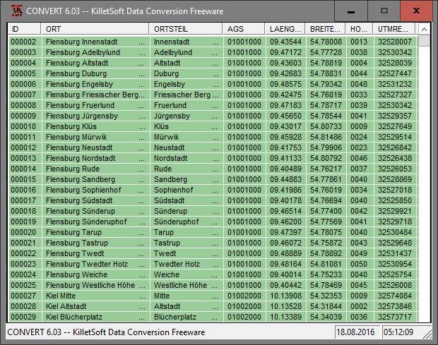
Press release from the publisher:The popular software program CONVERT is available as freeware for non-commercial purposes and can be downloaded from the website of the German software company Killet GeoSoftware Ing.-GbR (KilletSoft). The program converts data files between different file formats and character sets. It supports the file formats CSV (Comma Separated Value), SDF (Simple Document Format) and dBase (Borlands database format). In addition, data files are transferred to a character set of the standards ANSI, ASCII, UTF8 or UNICODE. For the import in MySQL or SQL databases the CREATE TABLE script can be generated. Thus the import of the data in any data base management system or file system will be possible. But CONVERT is not only a pure conversion program, because it allows the sorting of the data according to arbitrary criteria and allows horizontal filtering of data fields and vertical filtering of data records. A special feature of the program is the ability to process CSV and SDF files that are larger than 4.6 gigabytes (skipping 32-bit limit). More information you can find on the internet site http: www.killetsoft.de p_cona_e.htm.
Visit the Press Release for more details
Software from the publisher:GeoDLL, Geodata Germany, TRANSDAT (Deutsch), Graphics4VO Demo, Graphics4VO Graphics DLL 5.14, Geodata Germany, Geodata International, Geodaten International Streets 3.01, Geodata International, Geodaten International Houses 3.00, Geodata Germany, Geodaten German Streets 3.02, CONVERT, CONVERT (Deutsch) 3.03, Geodaten German Houses 3.02, Geodaten German Admin 13.04, Geodata International, GEODLL32 (English) 11.11, Graphics4VO Beispiel Programm 5.14, Graphics4VO Graphik-DLL 5.14, Geodata Germany, TOPOWIN, SEVENPAR (Deutsch), SEVENPAR (English) 1.10, ORTWIN, Geodaten International Admin 3.02, DRAGSENS, NTv2Tools, NTv2Poly, TRANSDATpro, GeoDLL, SEVENPAR, TOPOWIN, Geodata Germany, Geodata International, NTv2Creator,