Software Name:
TOPOWIN
Version: 11.10
Category: Business
Date Listed/Updated: 2011-03-05 13:49:11
File size: 4457 KB
OS: Win95,Win98,WinME,WinNT 3.x,WinNT 4.x,WinXP,Windows2000,Windows2003,Windows CE
License: Other Price($): 150.00
Author/Publisher name: Fred Killet
View Full Screenshot
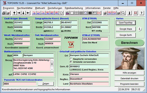
Description: TOPOWIN is a state-wide register of the German Topographic Cartographies, the German Basic Cartography and of localities with geo references in different coordinate systems. It is also a topographic information system. In the division of planning and execution of economical and scientific projects frequently topographic documents are used. The program TOPOWIN makes information available of the official topographic cartographies and the German Basic Cartography from the entire national territory in suitable graphic views. It accomplishes different coordinate transformations and inquiries. The program was developed under co-operation of the land surveying authorities of many German Federal States. For the first time in the previous version TOPO (for DOS) and later in TOPOWIN state-wide topographic information were arranged for the data technical evaluation. The program is for consulting engineers, planning authorities and users of topographic maps a useful and versatile tool. The topographical maps of different standards, required for a project, can be determined by the entering of known parameters or by the direct selection from overview graphics and from sorted lists. By the investigation of topographical records on the basis of known places, a data base with more then 105.000 places and residential districts is available. The program TOPOWIN calculates with Gauss Krueger coordinates and Geographic Coordinates refering to the Potsdam Datum (Bessel ellipsoid with central point Rauenberg). It also works with UTM coordinates and UTMRef coordinates in the NATO standard, which refer to the datum ETRS89 (GRS80 / WGS84, geocentric).

EULA

Tags: topography geodetics geography corner box coordinate map guide TK25 TK50 TK50 TK100 TKUE200 GK5 DGK5
Is this software spam? Report Spam
Software removal request by publisher Removal Request
Software Review: TOPOWIN Review
For publisher: Request Software Confirmation
Press release from the publisher:Geodetic Development Kit GeoDLL für Ihre eigenen GIS-Entwicklungen.
Schon seit vielen Jahren bietet KilletSoft unter dem Markenzeichen GeoDLL ein preiswertes Geodetic Development Kit an. GeoDLL ist eine einfach anzuwendende Programmbibliothek, die speziell für GIS-Experten und Software-Entwickler entworfen worden ist. GeoDLL ermöglicht den Entwicklern die zur Verfügung stehenden anspruchsvollen und präzisen Koordinatentransformation in ihre individuelle Geoinformatik-Software einbetten. GeoDLL enthält viele Geomatik-Tools für die GIS Entwicklung, wie das Erzeugen von Helmert und Molodensky Parametern, NTv2- und HARN-Gitterverschiebungen, INSPIRE und EPSG-Unterstützung, digitale Höhenmodelle (DEM), Entfernung und Zeitzonenberechnungen und die Fähigkeit, individuell passende Transformationsparameter zu verwenden.
Das Betriebssystem WINDOWS bietet Softwareentwicklern die Möglichkeit geodätische Funktionen aus der Dynamic Link Library GeoDLL in eigenen Programmen zu verwenden. Die Programmiersprache spielt bei der Verwendung einer DLL keine wesentliche Rolle. Allerdings ist die Nutzung der so entwickelten Programme zunächst auf Computer mit dem Betriebssystem WINDOWS beschränkt.
Zum Einbinden unter anderen Betriebssystemen und Hardware-Plattformen bieten wir die GeoDLL komplett als C++ Source Code an. Der Source Code ist weitgehend in ANSI-C geschrieben, so dass eine Migration auf beliebige Betriebssysteme und Hardware-Plattformen mit nur geringem Aufwand möglich ist. Weitere Informationen finden Sie auf der Internetseite https: www.killetsoft.de p_gdla_d.htm.
Visit the Press Release for more details
Software from the publisher:GeoDLL, Geodata Germany, TRANSDAT (Deutsch), Graphics4VO Demo, Graphics4VO Graphics DLL 5.14, Geodata Germany, Geodata International, Geodaten International Streets 3.01, Geodata International, Geodaten International Houses 3.00, Geodata Germany, Geodaten German Streets 3.02, CONVERT, CONVERT (Deutsch) 3.03, Geodaten German Houses 3.02, Geodaten German Admin 13.04, Geodata International, GEODLL32 (English) 11.11, Graphics4VO Beispiel Programm 5.14, Graphics4VO Graphik-DLL 5.14, Geodata Germany, TOPOWIN, SEVENPAR (Deutsch), SEVENPAR (English) 1.10, ORTWIN, Geodaten International Admin 3.02, DRAGSENS, NTv2Tools, NTv2Poly, TRANSDATpro, GeoDLL, SEVENPAR, TOPOWIN, Geodata Germany, Geodata International, NTv2Creator,