Software Name:
ORTWIN
Version: 8.10
Category: Business
Date Listed/Updated: 2011-03-05 13:49:24
File size: 4923 KB
OS: Win95,Win98,WinME,WinNT 3.x,WinNT 4.x,WinXP,Windows2000,Windows2003,Windows Tablet PC Edition 2005,W
License: Other Price($): 155.00
Author/Publisher name: Fred Killet
View Full Screenshot
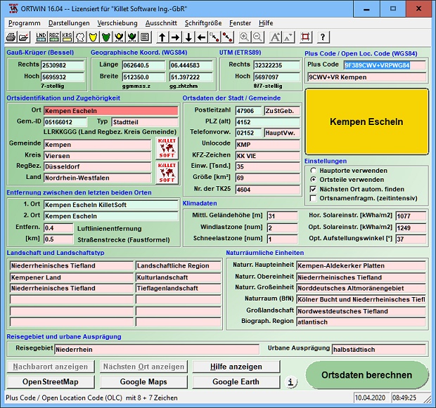
Description: ORTWIN is a program for the state-wide inquiry of the localities, postal codes and telephone selections in Germany. It finds postal zip codes, telephone pre selections, coordinates and ground level elevations. The program determines municipal codes, local center points, car license codes, topographic maps, Unlocodes and much more. It arranges localities hierarchically into the structures federal state, administrative district, rural district, town, municipality, local quarter and domicile. The program performs perimeter searches and distance calculations. It finds landscapes on different levels, natural units and snow- and wind load zones of all localities. In a radius around a place or around a postal code area covered localities and postal areas can be clearly represented by a comfortable perimeter search. They can also be arranged in a list, stored as a file and printed. For the local inquiries and perimeter searches a data base with more than 120.000 geo coded localities is available. The program represents local data, determined by local inquiries and perimeter searches, in graphic overviews and data lists. The program supports conversions between different coordinate systems and the distance calculation between the places. It calculates with Gauss Krueger coordinates referring to the Potsdam Datum (Bessel ellipsoid, Rauenberg) and with Geographic Coordinates on the geodetic datum WGS84. It also works with UTM coordinates, which refer to the datum ETRS89 (GRS80, geocentric). The functionality of the program is described in a detailed electronic manual. The program can be run on most common networks and it is possible to use Terminal Services on WINDOWS Servers. The client installations are done automatically.

EULA

Tags: local index register place locality town city cities quarter geo coding periphery perimeter search d
Is this software spam? Report Spam
Software removal request by publisher Removal Request
Software Review: ORTWIN Review
For publisher: Request Software Confirmation
Press release from the publisher:Zuordnung von Naturräumen und Landschaften zu allen deutschen Städten.
Killet GeoSoftware Ing.-GbR, Geo-Software-Entwickler mit Sitz am Niederrhein, stellt mit dem Produkt Geodaten Deutschland Fachdaten mit Raumbezug auf administrativer und postalischer Ebene zur Verfügung. Die Datenbanktabellen enthalten Geodaten der Bundesrepublik Deutschland mit Orten, Ortsteilen und anderen administrativen Einheiten, Postleitzahlen und Telefon-Vorwahlen. Die Daten sind mit Koordinaten für die Navigation und Geokodierung, für Umkreissuchen und Entfernungsberechnungen ausgestattet.
Seit kurzer Zeit können den Geodaten nun auch naturräumliche und landschaftsrelevante Informationen zugeordnet und in die Planungen mit einbezogen werden. Als naturräumliche Einheit wird im geographischen Sinne ein nach dem Gesamtcharakter seiner natürlichen Eigenschaften abgegrenzter Teil der Erdoberfläche verstanden. Die naturräumliche Gliederung lässt Rückschlüsse auf Naturräume und Regionen zu, die mit den abiotischen Faktoren Klima, Relief, Wasserhaushalt, Boden und geologischer Bau sowie mit den biotischen Faktoren Flora und Fauna ausgestattet sind. Eine neue Datenbanktabelle enthält die naturräumliche Gliederung der Bundesrepublik Deutschland in Form von hierarchisch gegliederten naturräumlichen Einheiten.
Der Begriff Landschaft grenzt deutlich gegen den Begriff Naturraum ab, da Landschaften sowohl durch natürliche als auch durch kulturelle Merkmale geprägt sind. Die ursprüngliche Naturlandschaft wird durch menschliche Einwirkung in Kulturlandschaft umgewandelt. Nach verschiedenen Kriterien werden Landschaftstypen definiert, die sich durchaus auch überdecken oder überlappen können. Sie sind in einer weiteren neuen Datenbanktabelle in Form der landschaftlichen Gliederung der Bundesrepublik Deutschland abgelegt.
Die Möglichkeit der Zuordnung landschaftlicher und naturräumlicher Informationen zu Städten, Gemeinden und anderen administrativen und postalischen Einheiten schafft neue Anwendungsgebiete. Denkbar wäre die Nutzung der Daten für Aufgaben des Naturschutzes, des Tourismus und bei der Gebietsplanung im weitesten Sinne.
Ausführliche Informationen und die Möglichkeit zum herunterladen kostenloser Testdaten finden Sie auf der Internetseite https: www.killetsoft.de.
Visit the Press Release for more details
Software from the publisher:GeoDLL, Geodata Germany, TRANSDAT (Deutsch), Graphics4VO Demo, Graphics4VO Graphics DLL 5.14, Geodata Germany, Geodata International, Geodaten International Streets 3.01, Geodata International, Geodaten International Houses 3.00, Geodata Germany, Geodaten German Streets 3.02, CONVERT, CONVERT (Deutsch) 3.03, Geodaten German Houses 3.02, Geodaten German Admin 13.04, Geodata International, GEODLL32 (English) 11.11, Graphics4VO Beispiel Programm 5.14, Graphics4VO Graphik-DLL 5.14, Geodata Germany, TOPOWIN, SEVENPAR (Deutsch), SEVENPAR (English) 1.10, ORTWIN, Geodaten International Admin 3.02, DRAGSENS, NTv2Tools, NTv2Poly, TRANSDATpro, GeoDLL, SEVENPAR, TOPOWIN, Geodata Germany, Geodata International, NTv2Creator,