Software Name:
NTv2Poly
Version: 5.04
Category: Miscellaneous
Date Listed/Updated: 2022-12-21 14:25:25
File size: 10796 KB
OS: Win2000,WinXP,Win7 x32,Win7 x64,Windows 8,Windows 10,WinServer,WinOther,Windows2000,Windows2003,Windows Server 2012,Windows Tablet PC Edition 2005,Windows Media Center Edition 2005,WinVista,Windows Vista Starter,Windows Vista Home Basic,Windows Vista Home Premium,Windows Vista Business,Windows Vista Enterprise,Windows Vista Ultimate,WinVista x64,Windows Vista Home Basic x64,Windows Vista Home Premium x64,Windows Vista Business x64,Windows Vista Enterprise x64,Windows Vista Ultimate x64
License: Other Price($): 185
Author/Publisher name: Fred Killet
View Full Screenshot
Description: The spatial software NTv2Poly replaces the rectangular activity scope contained in NTv2 files with a Polygonal Validity Scope, which is realized with an outline file in classic Shape Format. Invalid calculations outside the Polygonal Validity Scope thus can be excluded or acknowledged by a warning. Download the trial version from http: www.killetsoft.de zip ntv2poly.zip. Read the Worksheet at http: www.killetsoft.de t_1808_e.htm.
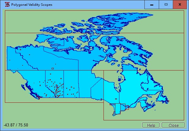
Using NTv2 grid files it is possible to transform points from one coordinate reference system to another with very high accuracy. An NTv2 file contains one or more quasi-rectangular coordinate grids which are defined in the NTv2 headers. Instead of a rectangular area only an embedded polygonal area should and must be covered, for example, a state territory within the country borders.
The program NTv2Poly realizes Polygonal Validity Scopes in NTv2 files. Using so prepared NTv2 files, coordinates outside the validity scope can be excluded from calculations or they can be acknowledged by a warning. This works with coordinate transformations using the geospatial software TRANSDAT and GeoDLL by KilletSoft and with many GIS programs which support Polygonal Validity Scopes.
The Polygonal Validity Scope is realized with a shape file, which contains the outlines of the scope as polygons. The file format Shape is developed by ESRI as a format for geographical objects. For example, in the shape file the border outlines of a country may be stored, which represent the polygonal scope for the NTv2 file used in that country. Using the program NTv2Poly the polygons of the shape file and the quasi rectangular surface of the NTv2 file are superimposed one on the other and processed in an ingenious manner.
The program has a user-selectable multi language interface and comes with extensive online help. The program can be run on most common networks and it is possible to use Terminal Services on WINDOWS Servers.

 We have affiliation with number one software market place Share-IT\. Contact us for better pricing/customised coupon code
 Use Avangate Coupoun code 548AAC3EB7 to get maximum discount. Please contact through skype: softrevu or send mail to submit@softrevu.com for better pricing
EULA

Tags: inserting insert polygonal validity scope scopes NTv2 binary file outlines outline shape shapefile p
Is this software spam? Report Spam
Software removal request by publisher Removal Request
Software Review: NTv2Poly Review
For publisher: Request Software Confirmation
Press release from the publisher:NTv2Poly is a new geospatial software for inserting area boundaries as Polygonal Validity Scopes in NTv2 files.
With the geospatial software NTv2Poly by KilletSoft the rectangular activity scopes of NTv2 files can be replaced by Polygonal Validity Scopes which are defined as area boundaries in classic shape files.
The NTv2 (National Transformation Version 2) file standard was developed by the Department of Natural Resources of Canada in the middle nineties. Using NTv2 grid files it is possible to transform geodata from one coordinate reference system to another with very high accuracy. An NTv2 file contains one or more quasi-rectangular grids with shift values. Instead of a rectangular area only an embedded polygonal area should and must be covered, for example, a state territory within the country borders. This article describes how Polygonal Validity Scopes can be realized in NTv2 files using a new developed software.
The program NTv2Poly developed by KilletSoft realizes Polygonal Validity Scopes in NTv2 files. Using so prepared NTv2 files, coordinates outside the validity scope can be excluded from calculations or they can be acknowledged by a warning. This works with coordinate transformations using the geospatial software TRANSDAT and GeoDLL by KilletSoft and with GIS programs which support Polygonal Validity Scopes.
The Polygonal Validity Scope is realized with a shape file, which contains the outlines of the scope as polygons. The file format Shape is developed by ESRI as a format for geographical objects. For example, in the shape file the border outlines of a country may be stored, which represent the polygonal scope for the NTv2 file used in that country. The polygons contained therein must be available as geographic coordinates in decimal notation. The reference system of the outline coordinates must correspond as closely as possible to the source reference system of the NTv2 file. A shape file in a different coordinate reference system can be converted into the required system using the geospatial software TRANSDAT by KilletSoft. Using the program NTv2Poly the polygons of the shape file and the quasi rectangular surface of the NTv2 file are superimposed one on the other and processed in an ingenious manner.
Visit the Press Release for more details
Software from the publisher:GeoDLL, Geodata Germany, TRANSDAT (Deutsch), Graphics4VO Demo, Graphics4VO Graphics DLL 5.14, Geodata Germany, Geodata International, Geodaten International Streets 3.01, Geodata International, Geodaten International Houses 3.00, Geodata Germany, Geodaten German Streets 3.02, CONVERT, CONVERT (Deutsch) 3.03, Geodaten German Houses 3.02, Geodaten German Admin 13.04, Geodata International, GEODLL32 (English) 11.11, Graphics4VO Beispiel Programm 5.14, Graphics4VO Graphik-DLL 5.14, Geodata Germany, TOPOWIN, SEVENPAR (Deutsch), SEVENPAR (English) 1.10, ORTWIN, Geodaten International Admin 3.02, DRAGSENS, NTv2Tools, NTv2Poly, TRANSDATpro, GeoDLL, SEVENPAR, TOPOWIN, Geodata Germany, Geodata International, NTv2Creator,